The birth of modern cartography
As well as winning numerous accolades as a general in the Sonderbund War, Guillaume-Henri Dufour was also a much-acclaimed cartographer who helped to invent modern cartography.

Andrej Abplanalp
Historian and communications chief of the Swiss National Museum.
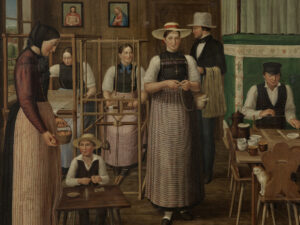
Switzerland is famous for delicious chocolate, accurate clocks, tangy cheese, and precise maps. Switzerland took the lead in map-making in the mid-19th century, when General Guillaume-Henri Dufour spearheaded a project in the canton of Geneva to create a geometrically accurate representation of Switzerland. The project was carried out between 1845 and 1864. The «Dufour Map» consists of 25 sheets and was drawn to a scale of 1:100,000. Using specially aligned strokes known as hachures, Dufour and his colleagues at the «Topographisches Bureau» were able to create representations of relief and rock formations with remarkable modelling and depth. This form of representation, which came to be called the «Swiss manner», received numerous international awards.
The Swiss Federal Council responded to the success of the map in 1863 by renaming the highest peak (4634 m) in the Swiss Alps, hitherto known as the «Gornerhorn», «Dufourspitze» as a special accolade to Dufour and his cartographers.
Virtual Dufour Map
Discover the first edition of the Dufour Map on the federal geoportal: map.geo.admin.ch
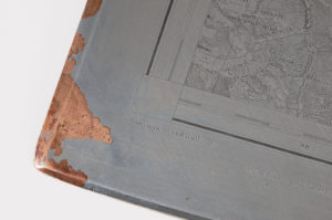
Copperplate engraving of the Dufour Map. Photo: Swiss National Museum
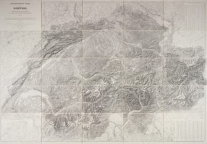
Dufour Map, 1845–1864, topographic map of Switzerland, produced under the supervision of Guillaume-Henri Dufour. Photo: Swiss National Museum
The end of an era
Signing off his final letter as “Directeur de la Carte Suisse” proved difficult. His hand shook, his pen hovered in mid-air and began to drop ink onto the paper. “Please excuse these inkspots, which appeared as I was closing my letter. I haven’t had the courage to resume it.” The mettle he had once had abandoned him at this landmark moment. For over 30 years, his nimble hand had penned thousands of letters, corrected drafts, checked his colleagues’ reports and written his own, rebutted criticism, forged some alliances by correspondence and prevented others. Now, however, it was complete: the Topographic Map of Switzerland, surveyed and published by order of the authorities of the Swiss Confederation, with data collected and scaled down by federal engineers supervised by General Guillaume-Henri Dufour.
“This is the last letter that I will ever have the honour of writing to you in my position in charge of the Topographic Map of Switzerland,” the soon-to-be 78-year-old general wrote to the Head of the Department of Military Affairs in late May 1865. “The Geneva office has closed, Lt Col. Siegfried has inspected its equipment and has signed the inventory.”
The cartographic cataloguing of Switzerland had been crowned with a detailed inventory of the instruments and devices used to survey the land: theodolites, measuring tables, printing plates, slide rules, protractors, sextants, optical distance meters, draughtsman’s and navigational compasses, pencils, pantographs, planimeters, lamps, logarithmic tables, books, maps, periodicals and much more. Enough to fill two entire railway trucks, which were now to be sent from Geneva to the Swiss capital. “All this equipment, packed into two wagons, must have arrived in Bern by train.” It was too late to change anything – other people were in charge now. All Dufour could do was hope that his work would be treated carefully in Bern. “[…] I’m hoping that Mr Siegfried will remove the cylinder containing the great Topographic Map of Switzerland straight away so that it can be taken to the federal palace. The rest can stay in the wagons until Mr Steinmann gets to Bern and retrieves them when he sets up the new office.”
He even showed his successor how the great map of Switzerland was to be arranged as well as urging him to handle it carefully and make sure it was well lit. Siegfried appears to have been keenly aware of what was being entrusted to him: “He really understood the significance of this document, which had moved the Confederation to make such major monetary sacrifices.”
David Gugerli is Professor for the History of Technology at ETH Zurich.