One of the border stones placed on Testa Grigia in 1938.
One of the border stones placed on Testa Grigia in 1938. Wikimedia/swisstopo

Plotting Switzerland’s borders: the case of Testa Grigia

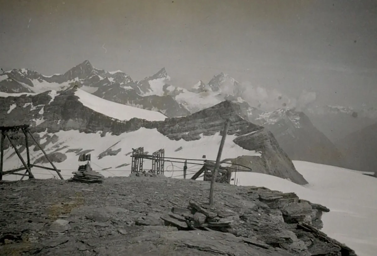
The construction of an aerial cableway from the Italian town of Breuil to Testa Grigia in 1937 alarmed the federal authorities as the terminus was located in the sensitive Swiss-Italian border area.
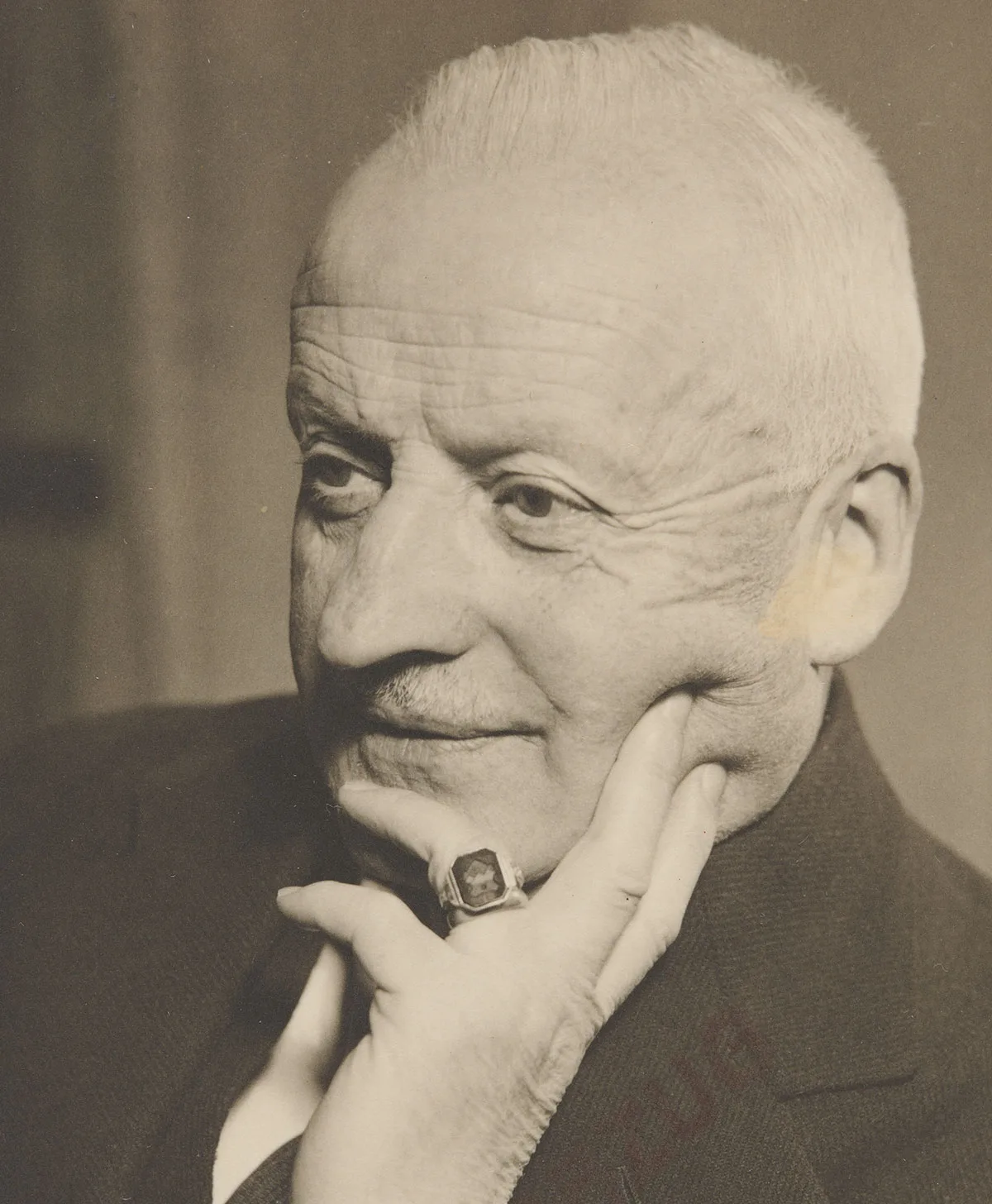
Felix Frey

Felix Frey

Felix Frey is a specialist in history at the Federal Office of Topography (swisstopo).

It was a project of unprecedented scale. In 1935, the Italian company S.A. Cervino started work on the construction of what at the time was the world’s highest aerial cableway. It went from the Italian town of Breuil in the Aosta Valley to the top of Testa Grigia at 3,479 metres altitude. Over a distance of 7.3 kilometres, the cable car climbed 1,450 metres and could transport 256 people an hour. This brought an end to the peace and quiet on Testa Grigia – which had previously only been visited by intrepid mountain climbers and dutiful border guards.

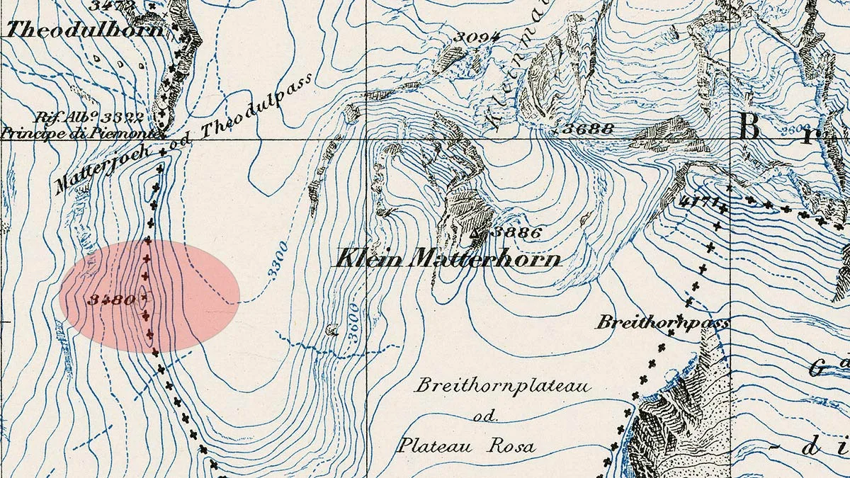
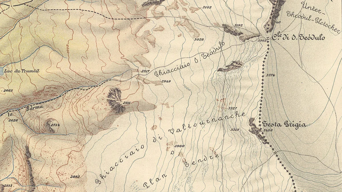
Two years after construction work got under way, the company S.A. Cervino contacted Switzerland’s representations in Turin and Rome as the site manager wanted to start work on the upper section of the aerial cableway. The last stop was to be on Testa Grigia, a rocky peak jutting out above the glacial lake. The Swiss-Italian border cut right through Testa Grigia. The construction project therefore touched the border area, which was particularly sensitive in 1937, as Switzerland’s relationship with the fascist regime under Mussolini strove to walk a fine line between compromise and distance.
Still not on the map: the Testa Grigia peak, located at 3,480 metres altitude (pink oval).
Still not on the map: the Testa Grigia peak, located at 3,480 metres altitude (pink oval). Topographic Atlas of Switzerland, sheet 535 ‘Zermatt’, 1933
The prospect of an Italian cable car carrying hundreds of passengers to the border every day caused some consternation in Bern, not least because – in the view of customs officials and the armed forces – the high mountain region was also a protective wall made of stone and ice. It impeded unauthorised border crossings, smuggling and military attacks. The construction of a cableway that would climb 1,450 metres in 20 minutes suddenly undermined that. The federal councillor responsible for foreign affairs, Giuseppe Motta, had serious misgivings in 1937.

The existence of a terminal stop […] that provides access to extensive ski resorts in Switzerland, also seems to pose a certain risk in terms of border control […].

Federal Councillor Giuseppe Motta in a letter to the Department for Post and Railways, 1937
Next to the cable car station, S.A. Cervino also wanted to build a restaurant, which was to be entirely on the Swiss part of Testa Grigia. However, Federal Councillor Rudolf Minger, head of the Department of Military Affairs, feared misuse of the restaurant building. In 1938 he called for the utmost vigilance, saying: “It is important to ensure – through strict, regular controls during the construction work – that no structural facilities are mounted that could be used for anything other than catering.” He was referring, for example, to an ammunition magazine or an underground tunnel to the terminus.

The Federal Council and the authorities concerned believed that it would be advantageous if the mountain station for the cable car was at least partly built on Swiss soil, believing that this would guarantee a certain degree of control over the operations on the remote peak. This is why the Italian construction company was assured in May 1937 that the necessary licence would be granted.
The Italian building project gave Federal Councillor Giuseppe Motto pause for thought. Portrait photograph from the 1940s.
The Italian building project gave Federal Councillor Giuseppe Motto pause for thought. Portrait photograph from the 1940s. Swiss National Museum

Work carried out under the radar

But in summer 1937, everything went quiet on the Testa Grigia issue – S.A. Cervino failed to get back to the Swiss authorities for months on end. On 29 July 1937, the Swiss Border Guard reported a surprising observation on Testa Grigia: without consulting the Swiss authorities, the company had stealthily installed an auxiliary track, built pylons for power and telephone lines, and carried out some of the blasting operations for the last stop on the cableway.

As the senior customs official reported, the Italians had assumed that the construction work on Testa Grigia didn’t affect Switzerland. According to the Italians, a copper boundary marker found in the rock on Testa Grigia provided evidence that the whole cable car terminal was to be built on Italian soil and that further negotiations with the Swiss authorities were therefore not needed.
Pylon (left) and auxiliary track (centre): the haphazardly-built structures on Testa Grigia, photographed in August 1937.
Pylon (left) and auxiliary track (centre): the haphazardly-built structures on Testa Grigia, photographed in August 1937. Swiss Federal Archives
The Director of the Federal Office of Topography, Karl Schneider, was quickly able to prove that the metal marker was not a boundary point. He showed that the marker was in fact a triangulation point and was completely on Swiss soil, and that in any case there was no boundary stone or border marker on Testa Grigia.

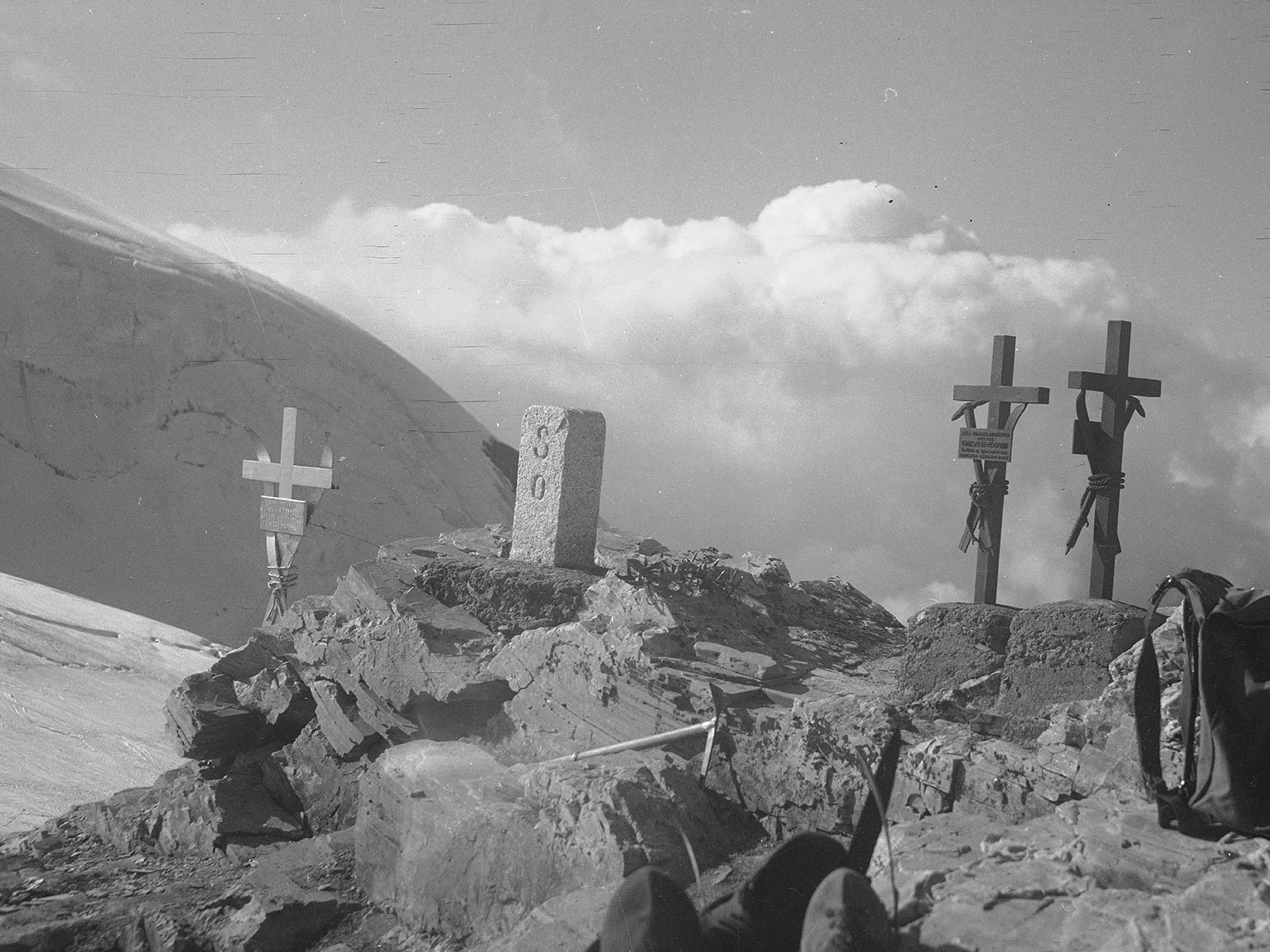
But Schneider’s intervention didn’t answer the question of where exactly the Swiss-Italian border lay as it was delineated only by the watershed. Where the water flowed from the rocky ridge to the Rhone was Switzerland, and where it flowed to the Po was Italy. The fact that the watershed was regarded as the border on Testa Grigia was a centuries-old rule, and the two countries had reaffirmed that it would continue to apply in 1931.
Along the watershed: the Swiss-Italian border on an Italian military map on a scale of 1:20,000.
Along the watershed: the Swiss-Italian border on an Italian military map on a scale of 1:20,000. Istituto geografico militare, ‘Monte Cervino, Conca del Breil’, Firenze 1922
The watershed line was the method of choice for defining borders in the high Alps as it saved complex measurement and border demarcation work in hard-to-reach areas. Instead, the two countries plotted the approximate course of the watershed on their official maps. But this line was not a precise border definition, merely an approximation. Karl Schneider therefore stressed: “We mustn’t consider this roughly plotted, slightly curved line as accurate in geometric terms and automatically transfer it to the terrain.” This would not suffice to determine exactly where the border lay on Testa Grigia in 1937. Instead, the two neighbouring countries had to travel to the site and work together to carry out detailed measurements of the exact course of the watershed to the nearest centimetre.

In view of the Italian building work taking place on Testa Grigia, by the autumn of 1937 it was clear that the exact border would have to be defined as soon as possible. The Federal Office of Topography called on the Italian-Swiss border commission to resolve the issue once and for all the following spring as soon as the snow on the peak had melted and more favourable weather conditions allowed an on-site inspection. The time finally came on 22 April 1938.
Border demarcations on Testa Grigia: dashed line as per the Italian military map, and line with crosses as per the Italian demands of April 1938. The dotted red line indicates the watershed line that was ultimately agreed and marked by five boundary stones.
Border demarcations on Testa Grigia: dashed line as per the Italian military map, and line with crosses as per the Italian demands of April 1938. The dotted red line indicates the watershed line that was ultimately agreed and marked by five boundary stones. Swiss Federal Archives
As reported by the Federal Customs Office, the binational border inspection faced two difficulties. First, it was virtually impossible to trace the natural watershed, “as the peak of Testa Grigia had been significantly changed in recent times by the preliminary excavation work for the construction of the cableway.” But the second issue was even more tricky to navigate: during the inspection, the representative of the Italian delegation, Major Lavizzari, claimed that the course of the watershed in fact meant that the whole of the summit of Testa Grigia was on Italian soil. Even on the ground it was difficult to trace the watershed in an entirely objective fashion. Negotiations were therefore needed to settle on an exact definition.

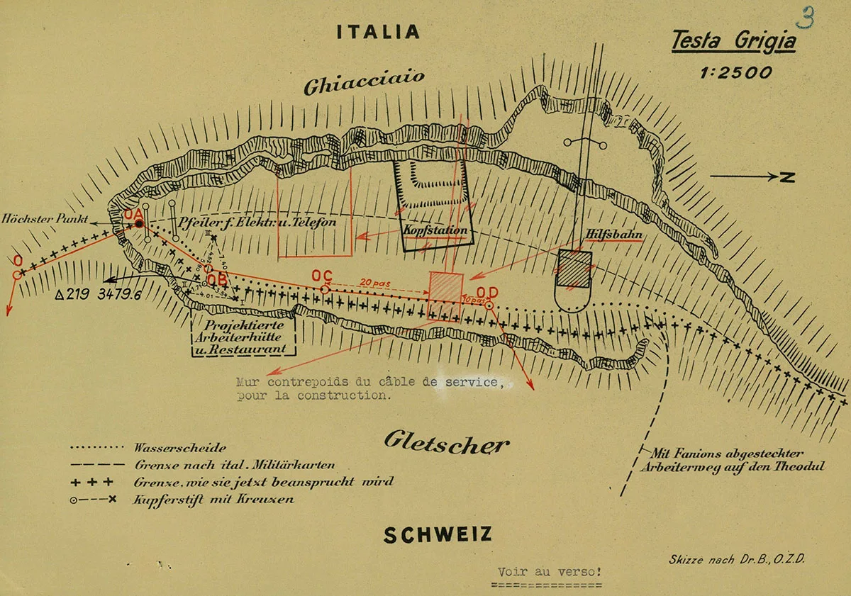
After lunch, Major Lavizzari returned to the matter, radically altered his position, and explained that there had been a misunderstanding. […] After much to-ing and fro-ing, we agreed on the border demarcation. It is clear that we can and must be satisfied with this boundary.

Colonel Schnetzer, head of the Swiss delegation, in his report on the border inspection
In May 1938, the agreed course of the watershed on Testa Grigia was demarcated with five boundary stones. The border ran in a straight line between the stones. It was therefore finally defined accurately enough to say clearly which building of the cable car complex was located on which side of the border.
Postcard of Testa Grigia from the 1940s. The Matterhorn can be seen in the background.
Postcard of Testa Grigia from the 1940s. The Matterhorn can be seen in the background. e-pics
The history of the national border on Testa Grigia shows how much work is involved in defining and plotting Switzerland’s seemingly self-evident borders. They are the product of numerous negotiations, conferences and on-site inspections, often taking place on rough terrain and in difficult weather conditions – because when precision is required, the line on the map is no longer enough.

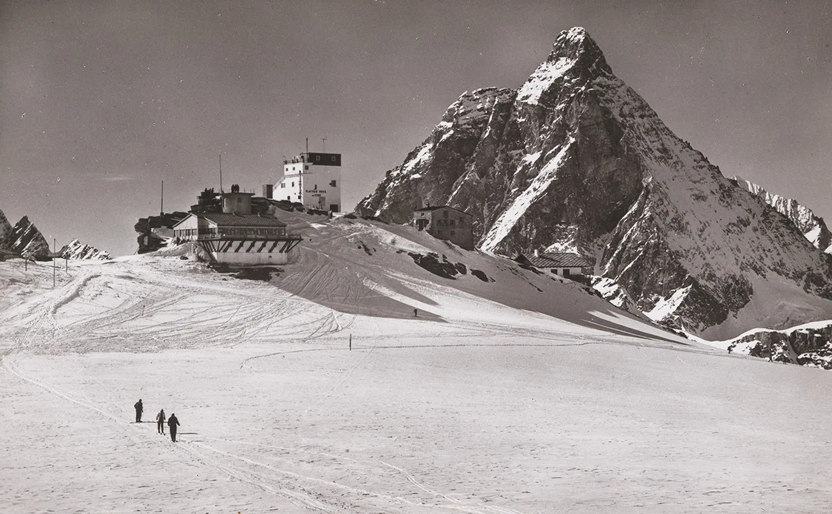
The Testa Grigia affair allowed the border question between Italy and Switzerland to be resolved by mutual agreement. The agreement paved the way for the completion of the aerial cableway, which had raised the issue in the first place. After four years of construction work, it started operating in March 1939.

Further posts