German or French playing cards? The ‘Brünig-Napf-Reuss line’ as a border for the use of French or German playing cards in Switzerland. Illustration based on a map from the “Atlas der Schweizerischen Volkskunde” collection.
German or French playing cards? The ‘Brünig-Napf-Reuss line’ as a border for the use of French or German playing cards in Switzerland. Illustration based on a map from the “Atlas der Schweizerischen Volkskunde” collection. SSSF Photo Archives, Basel / Swiss National Museum

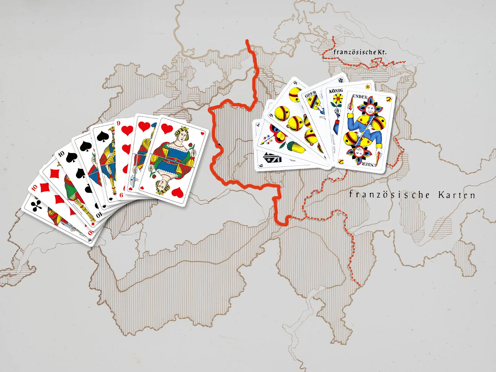
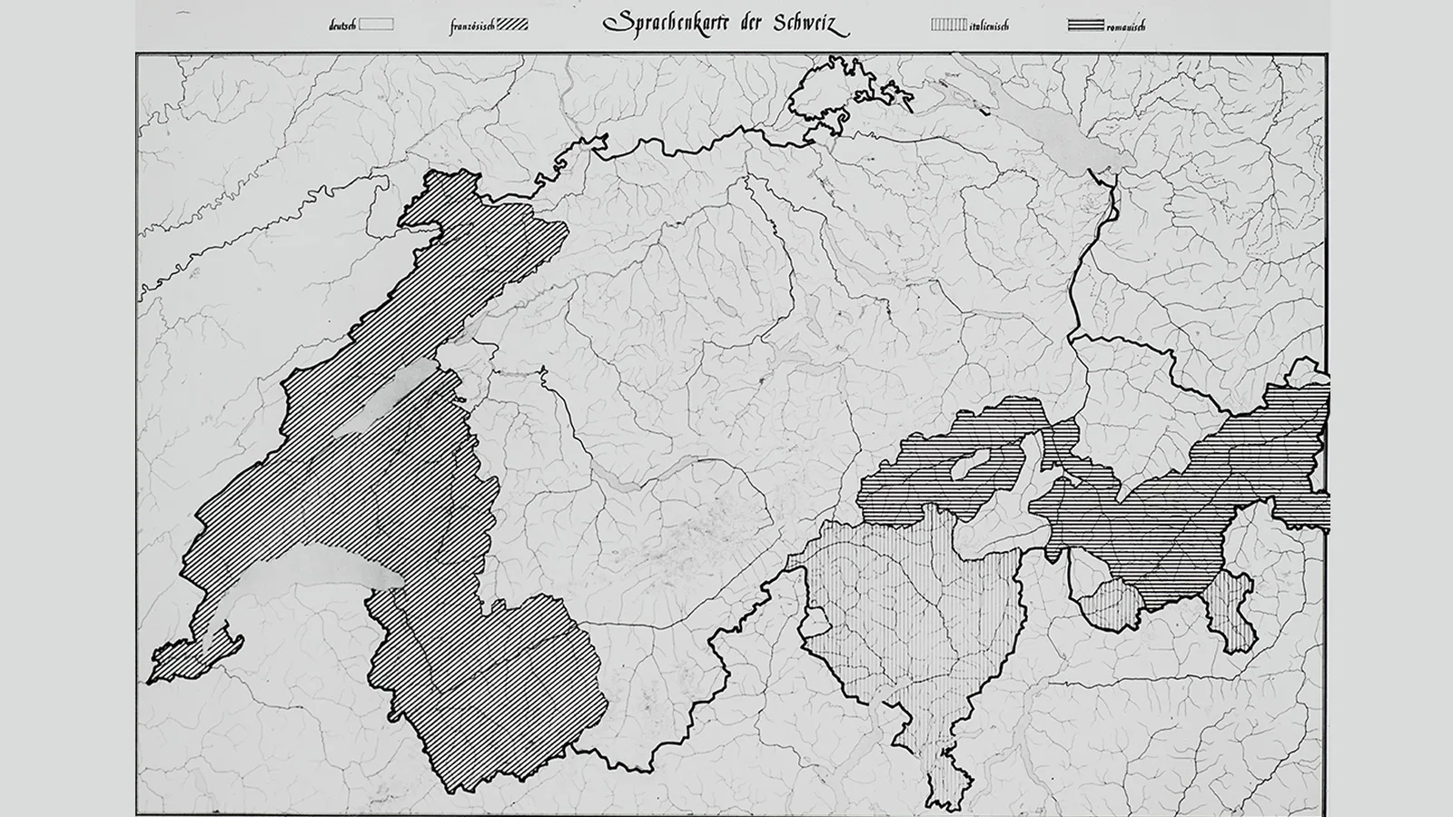
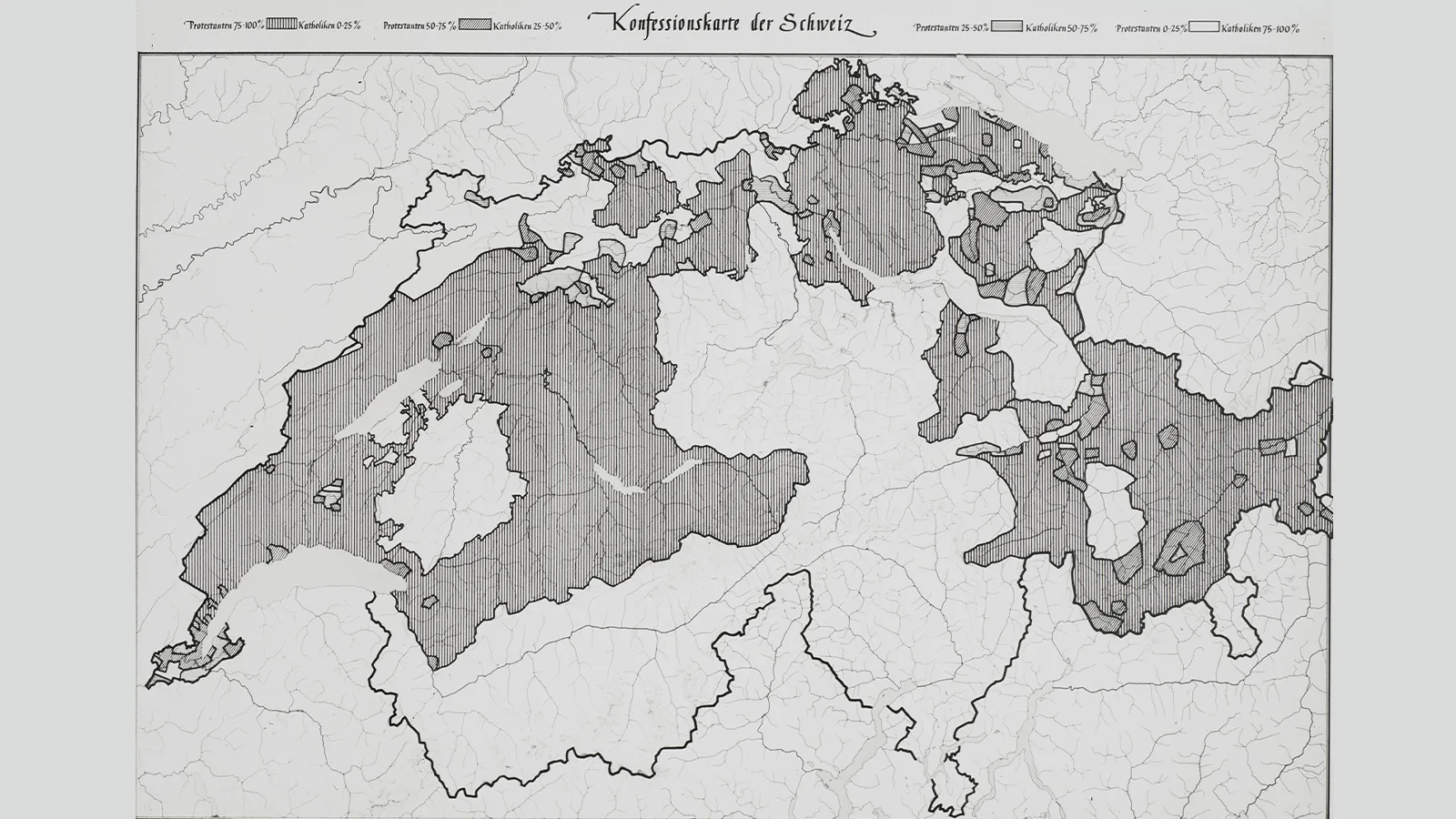
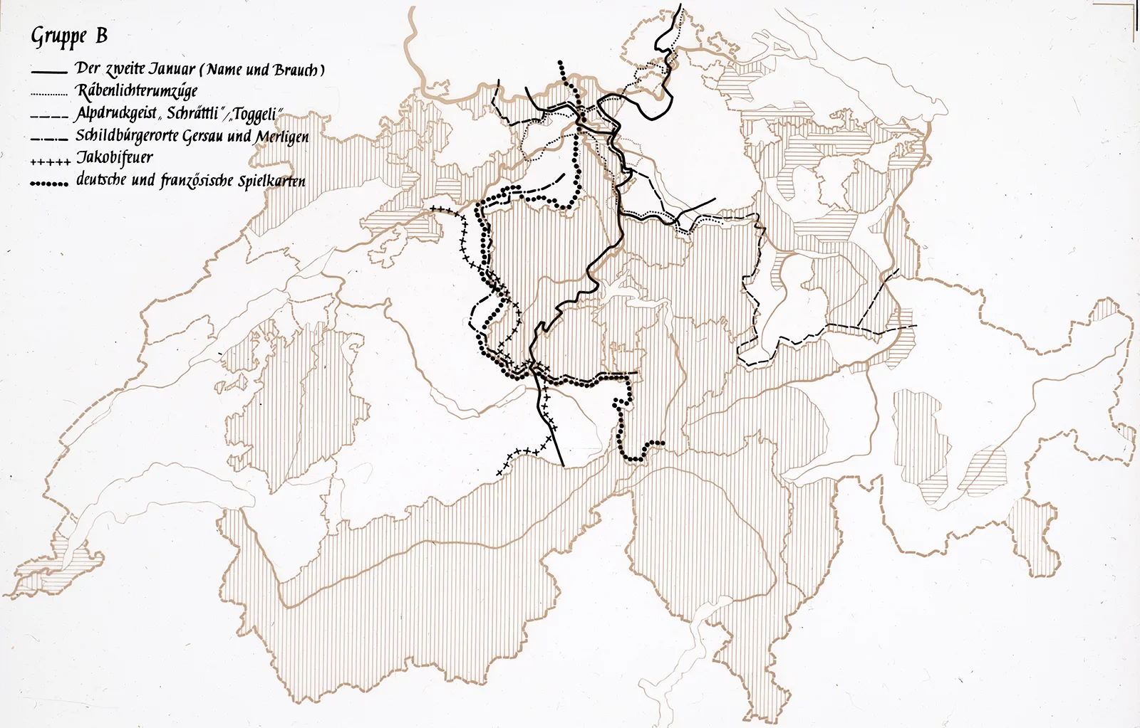
The Brünig-Napf-Reuss line: a cultural boundary through Switzerland 

The theory of a cultural divide running through Switzerland first emerged at the time of the “spiritual defence of the nation”, a time when academic research into folklore was being strongly promoted. This cultural boundary, which did not coincide with the language border, was supposed to provide evidence of national identity and cultural diversity.

Birgit Huber

Birgit Huber

Birgit Huber is a cultural anthropologist who is writing her Ph.D. thesis at the University of Basel on the “Atlas der Schweizerischen Volkskunde”.

The inaugural lecture for the newly created Chair of Volkskunde (the study of folklore and popular culture) at the University of Zurich was held on 16 November 1946. In a talk devoted to the “Swiss cultural area on maps depicting popular culture,” the newly appointed professor Richard Weiss spoke about his theory that cultural differences were to be seen not only along the language borders or the dividing line between the Alps and Central Switzerland. He posited instead that they could also be detected “along a border zone marked by the watershed between the Brünig pass, the Napf area and the lower reaches of the Reuss and Aare rivers.” In his inaugural lecture, Weiss named the ‘Brünig-Napf-Reuss line’ as a cultural boundary between the eastern and western parts of Switzerland. Dialect researchers had previously referred to a part of this divide, as had the “Sprachatlas der deutschen Schweiz” (the Language Atlas of German-speaking Switzerland). However Weiss had elaborated the idea of the extended line – most likely together with his colleague, Basel-based folklorist Paul Geiger – on the initial map designs for the “Atlas der Schweizerischen Volkskunde” (Atlas of Swiss Folklore). The two men were in charge of the atlas project, whose aim was to capture a cartographic snapshot of everyday life and customs in 1930s Switzerland. To achieve this, data was gathered between 1937 and 1942 in roughly 400 towns and villages. Around ten staff questioned some 1,200 people; with the exception of a few questions that they were to put directly to women, children or specific occupational categories, their task was, wherever possible, to find just one person in each place – be that mountain village or major city – who could speak on behalf of all the inhabitants in answering the 150 questions. They had three working days in which to complete the task in each location. The data collected provided extensive source material that was evaluated for cartographic purposes from 1942 onwards, initially by Weiss and Geiger themselves, who were soon joined by three other cartographers. The entire material is held in the archives of the Schweizerische Gesellschaft für Volkskunde (the Swiss Society for Folklore Studies) and is currently being made accessible in digital form as part of a research project.
Invitation to the inaugural lecture by Richard Weiss, Professor of Volkskunde at the University of Zurich, on 16 November 1946.
Invitation to the inaugural lecture by Richard Weiss, Professor of Volkskunde at the University of Zurich, on 16 November 1946. Zurich University Archives

The theory

While many people nowadays have heard of the Röstigraben, the French-German language border, the ‘Brünig-Napf-Reuss line’ is probably known primarily to those with an interest in folklore and popular traditions. The theory claiming that it forms a cultural boundary between the eastern and western parts of the country postulates that certain aspects of the culture differ along this line rather than on either side of the language divides. Weiss stated in 1946 that the line runs for the most part along the former boundary between Bern and the common bailiwicks, which continued at that time to divide the country along denominational lines. He believed it was precisely “insignificant” cultural assets that tended to get overlooked which showed specific regional variations. As examples of this, Weiss named the custom of serving up potato soup on Saturdays, the use of German or French playing cards or the name given to the figure that brings presents at Christmas. He believed that the distribution of these “insignificant” cultural assets enabled statements to be made regarding cultural movements. Weiss and Geiger were concerned to locate an (original) popular culture, a true “culture of the people”. In striving to map an “objective cultural area” and its borders, they were certainly also aware of the cultural complexity and cultural-historical development processes involved. And so they recorded many of their deliberations on procedures and data in annotations to the maps in the atlas.
Switzerland’s language borders. Glass slide from the “Atlas der Schweizerischen Volkskunde” collection of the SSSF Photo Archives, Basel.
Switzerland’s confessional boundaries. Glass slide from the “Atlas der Schweizerischen Volkskunde” collection of the SSSF Photo Archives, Basel.
Switzerland’s language (left) and confessional (right) borders on two glass slides. Richard Weiss and Paul Geiger probably used them when giving talks. SSSF Photo Archives, Basel / SSSF Photo Archives, Basel

The background

The theory that the ‘Brünig-Napf-Reuss line’ constituted a cultural boundary began to crystalise as early as the late 1930s. It was based on research work conducted in the 1930s and 1940s that bore the hallmark of the spirit of the times: of nationalism and the construction of a national identity via cultural traits, as well as National Socialism and fascism, war and mobilisation. The fact that the Atlas der Schweizerischen Volkskunde was in a position to contribute to the debate on the relationship between linguistic and cultural borders made it a good fit with the politico-cultural programme of the Geistige Landesverteidigung, a movement which sought to defend the spiritual independence of culture in Switzerland. On the one hand, the attempts to define the “popular culture” in the 1930s – and to answer the question: what is the common culture that unites a nation where four languages are officially spoken? – were very well received. The initial assessments produced by the research project emphasising that language borders and cultural boundaries were not necessarily identical additionally provided a scholarly justification for the national border line around the four language regions. On the other hand, after the end of the war in 1945, the same theory enabled those on the victorious side to position themselves politically by rejecting a “völkisch” form of scholarship, with its nationalist and racist overtones, and singing the praises of unity in diversity, a unity that transcends language and culture. But we shouldn’t forget that it was precisely this political situation which made it possible for the relevance of questions related to folklore studies to gain such recognition in the first place. And this was also one of the reasons for setting up a Volkskunde chair and for Richard Weiss’s inaugural lecture. Weiss had been teaching at the University of Zurich as lecturer since 1941. He was made professor in 1945, but as he wanted to complete the atlas first – which did not actually happen until 1995 – he postponed his inaugural lecture until 1946.
The border lines for various aspects of the culture on a single glass slide: Richard Weiss used this particular visualisation to argue in favour of the ‘Brünig-Napf-Reuss line’ as a cultural boundary.
The border lines for various aspects of the culture on a single glass slide: Richard Weiss used this particular visualisation to argue in favour of the ‘Brünig-Napf-Reuss line’ as a cultural boundary. SSSF Photo Archives, Basel

The repercussions

After that, Geiger and Weiss, and the three other cartographers who subsequently worked on the atlas, made no further reference to their theory of the ‘Brünig-Napf-Reuss line’ as a cultural boundary, apart from a couple of mentions at the start of the 1950s; neither did they test it on more recently published maps. However, until well into the 2010s, scholars were quick to cite the atlas project as an example of the way in which Swiss academia and science distinguished itself from National Socialism. Cultural anthropologist Konrad Kuhn addressed this issue along with the flaws in the argument in 2017: on the one hand, he found that the project and the newly established university discipline of Volkskunde had benefited enormously from the ‘spiritual defence of the nation’ – a movement which, among other things, created a growing interest in issues of popular culture and gave the discipline the opportunity to position itself in terms of identity politics. However, Kuhn was also able to demonstrate that networks had existed between Swiss and Nazi folklorists, and that Swiss scholars had even played a role in the rehabilitating the latter. For example, by inviting experts in the field who had been barred from their profession in neighbouring Germany to come and give lectures in Switzerland, they made it easier for the German scholars to be reinstated to positions at universities in their own country. Moreover, the narrative of an objective and politically neutral Swiss form of Volkskunde that distinguished itself from racially-oriented ‘völkisch’ studies remained in effect until the late 2010s, with the Atlas der Schweizerischen Volkskunde serving as a “showcase project”. This narrative prevented researchers from critically questioning their own perspective. The maps featured in the atlas and what they say about ‘cultural boundaries’ must therefore be viewed today with this in mind and placing them in the context of their time.
Glass slides of the “Atlas der Schweizerischen Volkskunde” being expertly restored in Regula Anklin’s studio in Basel. The slides were most likely used by Richard Weiss and Paul Geiger in talks.
Glass slides of the “Atlas der Schweizerischen Volkskunde” being expertly restored in Regula Anklin’s studio in Basel. The slides were most likely used by Richard Weiss and Paul Geiger in talks. Photo: Birgit Huber
At the beginning of the 1990s, Basel’s first female Professor of Volkskunde cast doubt on the ‘Brünig-Napf-Reuss line’, seeing it as a “myth perpetuated by Weiss”, while others prefer to speak less of a line and more of a “broad band”. The influence of these historical – political, economic and confessional – borders on the population and its activities remains undisputed. Today, when using the maps from the Atlas der Schweizerischen Volkskunde and the related ‘Brünig-Napf-Reuss line’ theory in arguments about earlier "cultural boundaries" in Switzerland, we need to pay attention to how the data was collected and evaluated at the time. To this end, we can hope for new insights from the current (digital) editing of the atlas material relating, for example, to questions of representation (whose data was collected and made visible, what and who became invisible in the process?) but also to questions of methodology (to what extent did the goal of visualising the data in map form shape the way it was collected, why was some of the data gathered not used for publication?). But in the end, it is basically also a question of how this ethnographic-historical collection can be made accessible digitally.

Multilingual Switzerland

15.09.2023 14.01.2024 / National Museum Zurich
In Switzerland, you can hear countless dialects, accents, types of slang and immigrant languages in addition to the four national languages. Visit the National Museum Zurich for a sensory journey through Switzerland’s language areas. Find out through interactive sound technology how the predecessors of our languages emerged, evolved or died out, how new linguistic and cultural borders arose and how they were (and still are) disputed.

Further posts